The monitoring station on a Brantford deep excavation site is a dense cluster of matte-black steel casings, solar panels, and weatherproofed data loggers mounted on a concrete deadman set just outside the shoring line. Inclinometer cables descend through a 65 mm PVC guide tube cemented into the till, while vibrating-wire piezometers register pore pressure shifts in the silty sand layer at 7 m depth. The data acquisition unit polls each sensor every 15 minutes and pushes the time series to a cloud dashboard that the geotechnical engineer and the shoring contractor review simultaneously. For excavations near the Grand River, where the Upper and Lower Terraces create abrupt changes in stratigraphy, a single shift in the groundwater table can alter the active earth pressure envelope on a soldier pile wall by more than 15 kPa. The instruments are calibrated to ASTM D7299 and CSA A23.3 tolerances, and the technician on rotation carries a field calibrator to verify zero drift before each 24-hour read cycle. When the cut approaches a heritage building on Colborne Street or a century-old trunk sewer on Murray, we often pair the inclinometer array with a seismic refraction survey to map the bedrock surface before the first bucket breaks ground.
A 5 mm cumulative prism movement over three readings in Brantford's glaciolacustrine clay is a signal to re-tension anchors before the deflection reaches the structural threshold.
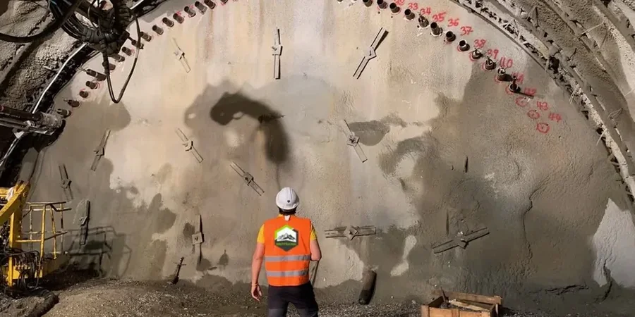
Process and scope
Local considerations
The contrast between a site on the Upper Terrace near the Brantford Municipal Airport and one down in the Lower Terrace by Lorne Bridge illustrates why uniform monitoring prescriptions fail here. The airport site sits on a thick sequence of Halton Till over limestone bedrock; deformations are typically slow, elastic, and recoverable if the excavation is short-term. The Lower Terrace site, by contrast, is underlain by up to 9 m of alluvial sand and silt with hydraulic communication to the Grand River, and the same 6 m cut can produce rapid, non-linear settlement bowls extending 25 m behind the wall. The difference in predicted lateral movement between a drained and an undrained analysis in the Lower Terrace sands can exceed 40 mm at the wall crest, which is enough to shear a cast-iron water main. Monitoring bridges this gap between prediction and performance: the piezometer data confirm whether the sand layer is draining toward the cut, and the inclinometer profile shows whether the deformation is deep-seated or confined to the upper 3 m. For deep excavations in the Lower Terrace, we often recommend coupling real-time monitoring with grouting for the alluvial sand unit to reduce permeability before the cut reaches the critical depth.
Video overview
Reference standards
The applicable standards include ASTM D7299-20 for verifying vertical incl
Associated technical services
Inclinometer and Settlement Monitoring
Continuous profile of lateral displacement using traversing probe inclinometers in 70 mm casing, paired with optical survey of settlement monuments. Data delivered via cloud platform with automated alert thresholds configured to the geotechnical design limits.
Piezometer and Groundwater Monitoring
Installation of vibrating-wire or standpipe piezometers at multiple depths to track pore pressure response during dewatering and excavation. Especially critical for Brantford sites within the Grand River influence zone, where river stage fluctuations directly affect excavation stability.
Crack and Vibration Monitoring
Pre-construction condition surveys with digital crack gauges and vibration monitors on adjacent structures within the zone of influence. Trigger levels set per OBC Part 4 and CNCC guidelines, with weekly reports submitted to the owner and the municipal building department.
Typical parameters
Questions and answers
What is the typical response time when a monitoring threshold is exceeded in a Brantford excavation?
The automated system sends an SMS and email alert to the project geotechnical engineer and the site superintendent within 5 minutes of a threshold breach. The engineer reviews the data remotely and can be on site within 2 hours for a Level 1 alert. For a Level 2 alert, which indicates a rate of movement exceeding 3 mm/day, the excavation crew is instructed to stop work in the affected zone and backfill the bench until a full stability reassessment is completed.
Does the City of Brantford require excavation monitoring for deep foundation permits?
The City of Brantford Building Department requires a geotechnical monitoring plan as part of the shoring permit application for any excavation deeper than 3.5 m or any excavation that extends below the footing level of an adjacent building. The plan must specify instrument types, locations, reading frequencies, and alert thresholds signed by a Professional Engineer licensed in Ontario. The monitoring data must be retained and submitted if requested during a municipal inspection.
What is the cost range for a comprehensive excavation monitoring program in Brantford?
How does the Grand River affect excavation monitoring requirements in Brantford?
The Grand River acts as a constant-head hydraulic boundary for excavations in the Lower Terrace. During spring freshet, the river can rise 2 to 3 m in 48 hours, and the resulting groundwater recharge can increase pore pressure at the excavation base within a day. Our monitoring plans for river-adjacent sites include real-time river stage data from the Grand River Conservation Authority gauges, correlated with piezometer readings, so the dewatering system can be adjusted before the hydraulic gradient destabilizes the excavation base.