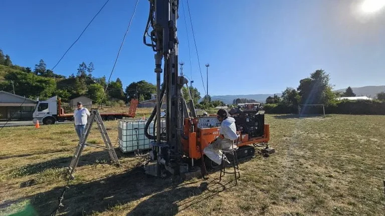
When a borehole log from the north end of Brantford shows a sudden transition from silty clay to sand till at 2.1 metres, the driller's field notes often carry a question mark next to the contact depth. That question mark is where an exploratory test pit becomes indispensable. The Grand River has reworked these deposits in ways that SPT spoon samples cannot fully capture, leaving pockets of organics and discontinuous sand lenses that only a continuous exposed face can reveal. Our team uses excavator-dug test pits to expose a clean vertical section, log the stratigraphy according to ASTM D2488, and extract undisturbed block samples for laboratory characterization. For projects near the Holmedale floodplain or along the 403 corridor where historical fill is common, the test pit provides a level of stratigraphic certainty that percussion drilling alone cannot deliver. Many geotechnical reports in the region combine SPT data with test pit logs to validate the lateral continuity of bearing strata, and we routinely integrate the findings with spt drilling programs to build a three-dimensional ground model that reduces the risk of mischaracterized foundation conditions.
A single well-logged test pit can resolve stratigraphic ambiguities that five boreholes leave unanswered — especially in Brantford's discontinuous glacial deposits.
Process and scope
Local considerations
Ontario Regulation 213/91 under the Occupational Health and Safety Act classifies most Brantford clay and silt as Type 3 soil, which carries a maximum unsupported vertical cut of 1.2 metres before shoring or engineered sloping is mandatory. A test pit that reaches 3 metres into a wet silty clay without a trench box is not just a regulatory violation — it presents a genuine collapse hazard that can trap a worker in seconds. The risk is compounded in the city's older neighbourhoods, where undocumented utility lines and abandoned foundations create additional instability in the trench walls. Before any excavator bucket breaks ground, the team locates all services through Ontario One Call, reviews historical aerial photography for former structures, and establishes a setback from adjacent footings equal to at least the pit depth. For deeper pits near existing buildings, a retaining walls design or temporary shoring system must be evaluated to protect the excavation and the neighbouring property. The geotechnical engineer notes the moisture condition of the pit face and records any seepage that could indicate a perched water table, which is particularly relevant in the low-lying areas south of the Grand River where spring melt can raise groundwater by over a metre.
Video overview
Reference standards
ASTM D2488-17e1 governs the visual-manual description and identification of soils; the Ontario Building Code (
Associated technical services
Stratigraphic Logging and In-Situ Classification
Detailed visual-manual logging of each exposed face per ASTM D2488, including Munsell colour notation, consistency/density assessment by pocket penetrometer and hand vane, and photographic documentation with scale. Contact depths are surveyed to site datum for integration with borehole logs and cross-sections.
Undisturbed and Disturbed Sampling
Collection of hand-carved block samples from cohesive strata for triaxial and consolidation testing, plus bulk disturbed samples in 20-litre pails for Proctor compaction and grain-size analysis. Sample handling follows ASTM D4220/D4220M-14 to preserve moisture content.
Groundwater and Fill Delineation
Observation of seepage zones at the pit face, measurement of water level after stabilization, and installation of a PVC standpipe piezometer during backfill. The pit log maps the upper surface of natural ground to delineate the thickness of anthropogenic fill, a critical parameter for Ontario Building Code foundation depth compliance.
Typical parameters
Questions and answers
What is the typical cost range for an exploratory test pit program in Brantford?
For a single test pit excavated to a depth of 2.5 to 3.5 The final figure depends on access constraints, the need for traffic control or utility locates, and whether a trench box is required for Type 3 soil deeper than 1.2 metres. Mobilization charges may apply for sites outside central Brantford.
How deep can an excavator-dug test pit go in Brantford's soil conditions?
With a standard 20-tonne excavator, depths of 4.5 to 5.0 metres are achievable in the stiff Halton Till that underlies much of the city. In the softer glaciolacustrine silts and clays near the Grand River, groundwater inflow often limits practical depth to around 3.5 metres. For investigation deeper than 5 metres, a drilled borehole with spt drilling is the preferred alternative.
Do I need a permit or utility locates before digging a test pit in Brantford?
Yes. Ontario One Call must be contacted at least five business days before excavation to locate public utilities. For private services beyond the demarcation point, a private utility locate contractor is recommended. If the pit is within the municipal right-of-way, a street occupancy permit from the City of Brantford is also required.
Can a test pit be used to determine the bearing capacity for a shallow foundation?
A test pit provides direct visual confirmation of the bearing stratum and allows sampling for laboratory strength testing, but it does not yield an in-situ bearing capacity number the way a plate load test or SPT N-value correlation does. The exposed face lets the geotechnical engineer verify that the competent till is continuous and unweathered, and block samples can be tested in a triaxial cell to obtain drained strength parameters for bearing capacity calculations.
How is the test pit backfilled, and will it settle over time?
The excavated material is placed back in lifts of 250 to 300 mm, each compacted with a vibratory plate compactor to at least 95% of Standard Proctor maximum dry density. The top 300 mm is mounded slightly to allow for natural settlement. For pits in landscaped areas or under future pavement, imported granular fill with compaction testing by sand cone density may be specified to minimize long-term subsidence.